infocus
Map Activities
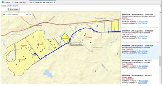
Map Activities provides a simplified approach to viewing and updating data in X-Info Connect and X-Info WebConnect. A Map Activity displays data relevant to users visually in a map and enables you to communicate tasks and outcomes in a clear and engaging way.
Q1: What can be done from a Map Activity?
A1: A user can use a Map Activity to search for data within the application and display results in a map. Once a map is displaying, other functions can be used to assist users with daily work activities such as displaying spatial data and displaying different layers in a map, viewing more information about the features in a map, or accessing related data in the same or new tabs – allowing a user to complete tasks using contextual activities.
Q2: Can our own data be imported into a Map Activity?
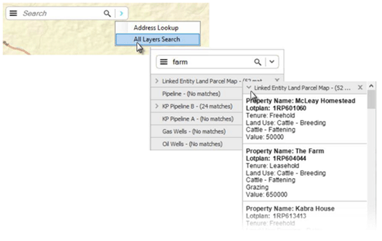
A2: Yes! A Map Activity is made up of layers which are shown in the map display and can be turned on and off by the user. This can include Internal Data (such as geometry fields in X-Info Connect), External Data (spatial data from external sources such as WFS, WMS, Tile Services, Shape/Tab files, ESRI Rest Services, Post GIS and others) and a Geocoder (datasets like Open Street Maps that enable street address searching).
Q3: Can one or multiple layers in the Maps Activity be searched on?
A3: Layer searches can be set up by an Administrator and can be configured to include one or many layers in the search. Users can enter text to search across single or multiple layers included in the map search. The results will display grouped by layer name with the number of matches in brackets.
If you would like further information or assistance setting up a Map Activity in your application, please contact the Mipela Support Team at support@mipela.com.au.
Popular Posts
A word from the BossEffective land management across the Gas Pipeline Victoria
It’s the stuff you don’t see that’s keeping you safe
x-infocus tips and tricks
Ampol joins our Client Community!
#projectMAD Special Invitation (14th Year) – RideWithUs!
Staff profile
I’m in a pickle
OLDER POSTS
A Word from The Boss
Mipela are Proud to Protect Qeno’s Botany Assets using the Power of X-Info Assurance suite
Update on our process improvement Kamapim project
x-infocus
Product Update
Mousemats
Staff Updates
Ensuring Smoother User Management: Your Collaboration can Expedite the Process
SA Power Networks – Committed to Ensuring Security
‘Tis the Season
A Word From The Boss
Our cloudy outlook has never looked so rosy
Update on our process improvement Kamapim project
infocus
Product update
Let us in!
Staff update
Providing you that extra level of assurance
Do you have reporting fatigue?
Mipela has invaded New Zealand!
A Word From The Boss
Focus on the complex, the urgent and the sensitive
Update on our process improvement Kamapim project
Making light work of Safety Management Studies
Safeguarding access and data integrity – the significance of using personal credentials to log onto software
A Word from the Boss
Reporting Stakeholder Information to the Regulators
Global Excavation Safety Conference awards Australia’s Glen “Cookie” Cook as the World’s Damage Prevention Hero of the Year 2022
Adding extra assurance to your BYD automated response system
A word from The Boss
APGA POG Incident database
What integration with SPEAR means to Jemena
Sentanil product focus
A word from The Boss
A truly epic project
The true power of data automation for Jemena
Update on our process improvement Kamapim Project
A word from The Boss
Tweed Shire Council using technology to deliver value to ratepayers
Women in Pipelines Forum (APGA)
A word from the Boss
Using software to safely plant trees
How mapping retirement homes helps LendLease manage its 14,000 dwellings
Utilising Map Activities
When it rains it pours
A word from The Boss
Stakeholder management and a global wind energy company
ERA Water automates its asset protection with X-Info DBYD suite
A word from the Boss
ARTC implements X-Info DBYD suite as their automated response system
Beware the Spreadsheet
If you are breaking ground out in the field – we have you covered!
A word from the boss
When community focus is key to the success of your project
How Gladstone Area Water Board saves time processing permits using X-Info DBYD suite
Mipela delivers more efficiencies to APA Group
Helping protect Queensland assets is at the tip of your fingers
Responsive engagement, requires intuitive interactions
Managing Cultural Heritage across Barada Barna land
“The Power of Communication” – see your world from a new perspective
Ever wondered how TransLink manage their Bus Stops?
Managing contaminated land compliance
APGA moves Pipeline Engineers Competency System (PECS) to a a new platform
“Doing the right thing”
Systematising pipeline risk management
The APGA Knowledgebase has moved to a new platform
These are challenging times
Experience really counts when it comes to stakeholder management
City of Greater Dandenong implements DBYD automated response system
Some days are great, some days are good, some days are bad
Stakeholder management – the answer is blowing in the wind
Flavour of the month – renewable energy projects
3 proven ways to empower technology
Automation in Remote Regions Delivers Multiple Benefits to Council
Powering through South Australia
Bringing together data, systems and people
There’s no watering down the importance of DBYD responses at Allwater
Tanami Gas Pipeline data integrity and materials traceability
Incident management and risk analysis of Australasia’s pipelines
Greater Shepparton City Council moves to X-Info DBYD suite
What is X-Info SMS suite?
Putting your pipeline Safety Management Study information in one place
Making Lodging DBYDs Easier
Drawing in the Power of Collaboration
Desktop GIS Analysis for Preliminary Route Selection
X-Info DBYD suite Perfect Fit for ATOM
First Gas Land Management
Managing Your Information
Managing Your Information – from beginning to end
The importance of data across the life of your assets
Mipela assist Luminous Energy in planning solar farms in Queensland
Tasmanian Irrigation
The Value of X-Info Plans Management – Zinfra
Together, we grow
X-Info Plans Management
Real time data capture and reporting in remote field environment made possible with X-Info Aware
X-Info SMS suite – Safety Management Study
Property Information Service made easy
Your competitive advantage in field service management
Remote field task management and data capture providing results for real time consumption for Veolia
TGP optimises their field workforce with mobile data capture app
More than just maps… How do we add value to your GIS?
Working together as a team towards greater success
Automated back end processes provides Gladstone Area Water Board with improved responsiveness for issuing of permits
Four steps for effective business process improvement
Field Data Conversation Efficiency
Treasure your data?
New, bold, brilliant – X-Info Aware
SEA Gas improves efficiency of land management
Reach your business potential with X-Info Aware
Perfect match: X-Info Connect and Maintenance Connection
News Archive
- Summer 2015
- Spring 2015
- Winter 2015
- Autumn 2016
- Winter 2016
- Spring 2016
- Summer 2016
- Autumn 2017
- Winter 2017
- Spring 2017
- Summer 2017
- Autumn 2018
- Winter 2018
- Spring 2018
- Summer 2018
- Autumn 2019
- Winter 2019
- Spring 2019
- Summer 2019
- Autumn 2020
- Winter 2020
- Spring 2020
- Summer 2020
- Autumn 2021
- Winter 2021
- Spring 2021
- Summer 2021
- Autumn 2022
- Winter 2022
- Spring 2022
- Summer2022
- Autumn 2023
- Winter 2023
- Spring 2023
- Summer 2023
- Autumn 2024
Tags
- Stories from our clients (49)
- A word from the boss (Hayden McDonald) (22)
- X-Info DBYD suite (12)
- Product news (10)
- X-Info Suite (9)
- X-Info Connect (8)
- X-Info Aware (6)
- GIS (6)
- X-Info Assurance suite (6)
- X-Info SMS suite (5)
- X-Info Plans Management (5)
- X-Info Stakeholder Management (4)
- x-infocus Technical "how to's" (3)
- Works Management module (3)
- X-Info Lands Management (2)
- Stakeholder management (2)
- X-Info WebConnect (2)
- X-Info Service suite (1)