
With increasing development, your underground assets are at risk more than ever before and the number of referrals you receive will continue to grow. Unfortunately, responding to the volume of enquiries coupled with the repetitive process of producing response documentation and maps is an onerous task that is prone to errors and inconsistencies.
Community and staff safety is a priority for any business. It is imperative the processing of Before You Dig (BYD) enquiries is handled in an accurate, consistent and timely manner.
![]() X-Info Assurance suite is a workflow process software solution, developed by Mipela GeoSolutions, that automates the response process, saving you time and money. The process brings efficiency and control to protecting your underground assets. It also prevents damage and disruption to the vast underground pipe and cable networks which provide Australia with the essential services we use every day – electricity, gas, communications and water.
X-Info Assurance suite is a workflow process software solution, developed by Mipela GeoSolutions, that automates the response process, saving you time and money. The process brings efficiency and control to protecting your underground assets. It also prevents damage and disruption to the vast underground pipe and cable networks which provide Australia with the essential services we use every day – electricity, gas, communications and water.
X-Info Assurance suite is a registered and certified Australian Made product.
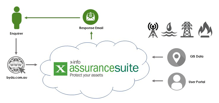
X-Info Assurance suite at a glance
More about the X-Info Assurance suite process
X-Info Assurance suite is a cloud hosted software solution that protects your underground assets (stormwater, water mains, sewerage, fibre optic, etc.).
X-Info Assurance suite enables BYD enquiries to be automatically processed, providing detailed plans to the enquirer within seconds, saving you time and money, reducing human error, ensuring transparency of activities near your assets and most importantly protecting your assets and people from incidents 24 hours a day, seven days a week.
Enquiries from the BYD pre-excavation referral service are received by X-Info Assurance suite on behalf of its asset owning clients via a webhook. X-Info Assurance suite receives and processes the file, creates a map and written response in PDF format and then automatically generates a response that is sent back to the enquirer – in seconds. This response clearly outlines, if their operations will encroach on your assets, and what action needs to be taken, if any. The response is then archived for future reference within X-Info Assurance suite. The complete process requires little or no human intervention. However, response emails can be directed to an internal email address for review prior to being forwarded on to the enquirer, if necessary.
X-Info Assurance suite’s browser based user interface – with powerful search capabilities and workflow automation – requires no software to be installed for users. X-Info Assurance suite generates detailed reporting, provides data exports, tracks communications, manages follow up actions and has the option to include permit to work activities (Works Management module).
- GIS independent – X-Info Assurance suite delivers high quality outputs regardless of the client’s choice of GIS
- Peace of mind – Mipela has been providing automation for the energy, infrastructure and local Government sectors for 25 years
- Fully managed solutions – with priority service from the Mipela Support team
- User friendly – access to a user friendly interface via a secure URL, providing benefit to cross sections of your business
- Consistent and accurate responses – reduce human errors with reliable automated quality outputs
- Flexible – Mipela Support team can add new asset layers at anytime
- Data interrogation – using the comprehensive reporting tools in your secure portal
- Visualise activity near your service and community assets with the included mapping features
- Integrate with your corporate GIS and IT systems through configuration
- Save time and money by automatically responding to requests.
- Secure browser based user interface
- Interactive mapping interface
- Track associated interactions (emails, phone calls, meetings, etc.) with an enquiry
- Extensive reporting options
- Integrates with Mipela’s other software to provide additional workflow automation.
System Requirements
Operating System
Minimum Windows Server 2016
Software Required
Modern browser – Chrome, Edge, IE11 or higher
Email Setup
- IMAP enabled server or Exchange Server with EWS enabled
- The email server is expected to receive large volumes of traffic. It is recommended the server has no traffic restrictions or limitations.
Web Server Options
- IIS 8.0 or higher
- .Net 4.0
Supported Formats
GIS Vector Data Formats
- MapInfo TAB format (excluding MapInfo Grid files)
- Esri ArcView Shape file (SHP)
- Oracle Spatial tables (9 or later)
- GML and KML files
- SQL Server Spatial
- Esri File Geodatabase
- Esri REST Services
- PostGIS
Web Services
- Web Feature Services (WFS)
- Web Mapping Services (WMS)
- Esri REST Services
GIS Raster Data Formats
- GeoTiff (TIFF)
- ECW – ERmapper Compressed Wavelet (with internal geo-referenced header information or tab header file)
- JPEG – JPG (with world file – jgw)
- JPEG2000 – jp2
Databases Supported
- SQL Lite
- SQL Server
- PostGIS
System Architecture
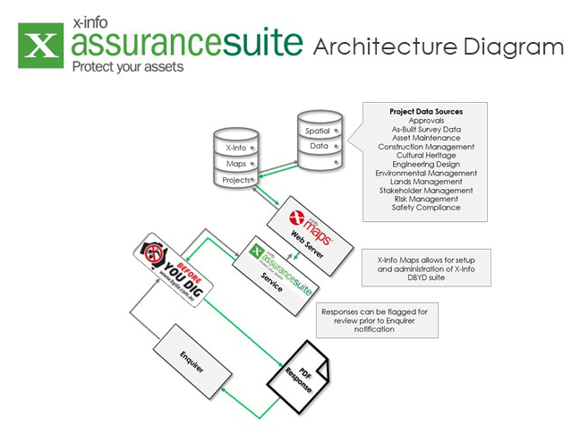
Key applications
We provide workflow process software solutions and services to many of Australia’s most significant underground asset owners.
Current sectors
- Electricity
- Gas
- Communications (telco, cable, fibre optic)
- Water
- Local Councils (stormwater drains, sewerage infrastructure, irrigation and network cabling)
Case studies
ARTC


Central Highlands Regional Council
City of Port Phillip

City of Rockingham

City of Sydney

ElectraNet
Epic Energy

Gladstone Area Water Board

Mackay Regional Council

Tweed Shire Council